Check list
ü Do you know the layers of the earth?
ü Can you
explain convection currents?
ü Do you know
the difference between oceanic and continental crust?
ü Can you draw a
labeled diagram of the major plate boundaries (constructive, destructive and
conservative)?
ü Do you know
how we measure and monitor earthquakes, tsunamis, and volcanoes?
ü Can you
describe the difference between a shield and a composite volcano and how they
are formed?
ü Can you
describe the cause, effects and responses to our case studies (Haiti, New Zealand,
Japan tsunami, Boxing Day tsunami, Montserrat and Eyjafjallajökull)?
ü Can you
explain the formation of a caldera from a supervolcano?
ü Can you
describe the impacts and responses to a supervolcano?
ü Can you
describe how fold mountains are formed?
ü Can you use
our case study (The Alps) to describe how fold mountains are used?
1. The Earth’s Crust is unstable, especially at plate margins.
Inner core – this is the hot solid centre of the Earth made up of iron and nickel.
Outer core – this is the liquid layer within the core, also made up of iron and nickel.
Mantle – this is the thickest layer of the Earth. It is a semi- molten layer which is ductile enough to flow.
Crust – this is the outer layer of the Earth made up of several plates. It is thin, being just 5 -70km.
Types of crust
There are two types of crust oceanic and continental. Continental crust is thick, less dense, older and overland. Oceanic crust is thin, new, dense and found under the sea.
Plate Boundaries
1. The Earth’s Crust is unstable, especially at plate margins.
Inner core – this is the hot solid centre of the Earth made up of iron and nickel.
Outer core – this is the liquid layer within the core, also made up of iron and nickel.
Mantle – this is the thickest layer of the Earth. It is a semi- molten layer which is ductile enough to flow.
Crust – this is the outer layer of the Earth made up of several plates. It is thin, being just 5 -70km.
 |
| Source: BBC Bitesize |
Types of crust
There are two types of crust oceanic and continental. Continental crust is thick, less dense, older and overland. Oceanic crust is thin, new, dense and found under the sea.
Plate Boundaries
The Earth is split into several plates:
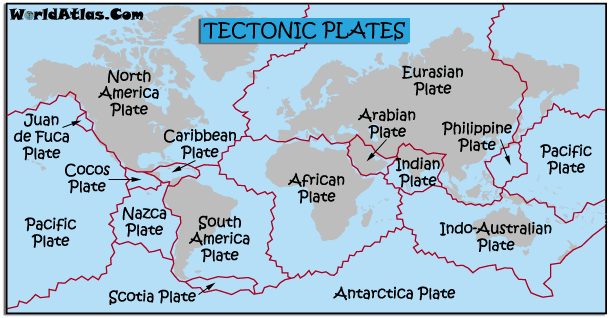 |
| Source: Worldatlas |
These plates are moved by convection
currents in the mantle. The heat from the radioactive decay and pressure in
the core heats the base of the mantle. The magma becomes less dense and rises.
As it moves away from the core it becomes dense again and sinks. This movement
moves the crusts slowly destroying parts of the crust and creating new parts.

bitesize video link
There are 3 main types of plate boundaries. You need to be able to
explain them and draw a diagram (remember if the exam question just needs a labelled
diagram then you need to add all of the explanations into the annotations).
Destructive
plate boundaries
A destructive margin occurs when an oceanic crust and a continental
crust move together due to convection currents in the mantle. The oceanic
crust is subducted underneath the less dense continental crust forming an ocean trench. Friction between the
plates causes earthquakes and the crust to melt into the mantle. As pressure
builds up magma rises through the cracks in the rock and eventually erupts
forming a composite volcano. Behind
this a volcanic mountain chain forms over
time.

Constructive
plate boundaries
At a constructive margin two oceanic
plates move away from each other due to the direction of the convection
currents in the mantle. As the plates move apart, magma rises from the mantle
to fill the gap creating new land called a mid-ocean ridge. Shield volcanoes
occur at these plate boundaries. Example: Mid-Atlantic Ridge between the Eurasian Plate and the North American Plate.

Conservative Plate Boundary
Here two plates are moving in different directions (or the same direction but at different speeds.) As the plates move past each other it causes friction. When this friction is released in a sudden movement an earthquake occurs. Example: San Andreas Fault, North America.

Types of Volcanoes
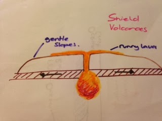
Shield Volcano
Shield volcanoes are generally found on constructive plate boundaries. The lava here has a low silica and gas content therefore they do not erupt violently and the lava is very runny. This forms low, gentle sloping volcanoes which erupt regularly.
Composite Volcano
Composite volcanoes are generally found on destructive plate boundaries. The lave has a high silica and gas content and is therefore viscous and explosive. They produce violent explosions where large ash clouds and pyroclastic flows are present. This results in alternative layers of ash and lava. As the lava is viscous it does not run very far before it cools producing steep sides to the volcano.

Pause and test your self: Exam Questions
1. Draw a labeled diagram to demonstrate how volcanoes form at constructive/destructive plate boundaries. (4)
2. Explain the difference between oceanic and continental crust. (4)
3. Using a diagram, explain how earthquakes occur on a conservative plate boundary. (4)
3. Using a diagram, explain how earthquakes occur on a conservative plate boundary. (4)
4. Draw an annotated field sketch of the image. (4)
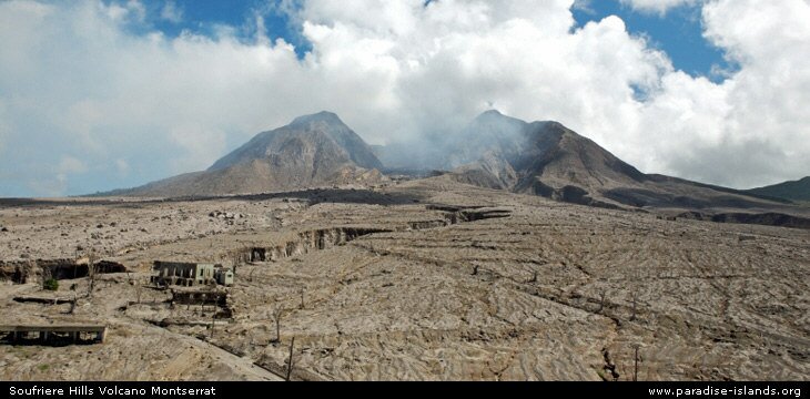
Source: www.paradise-islands.org/montserrat/volcano.htm
5. Describe the difference between the epicenter and the focus. (2 marks)
Earthquakes
Measuring and monitoring Earthquakes
There are two main ways of measuring an earthquake these include the Richter Scale which measures the energy released during an earthquake and then gives it a number on a logarithmic scale. A seismograph is used to measure the shaking.


The second is the Mercalli Scale which measures the effects of the earthquake.

Three Ps
Prediction- this involves monitoring and forecasting
Protection - this involves designing and building appropriate infrastructure
Preparation- this involves preparing drills for the population and emergency services to educate what to do in an event of a hazard in order to reduce the casualties.
Prediction- this involves monitoring and forecasting
Protection - this involves designing and building appropriate infrastructure
Preparation- this involves preparing drills for the population and emergency services to educate what to do in an event of a hazard in order to reduce the casualties.
 |
| Source: AQA A Geography book |
Earthquake
Haiti earthquake, 2010
Magnitude: 7.0
Total death: 220,000
Injured: 500,000
People homeless: 1.5 million
Watch the video to develop your understanding of the disaster.
Immediate responses
The impacts of the Haiti earthquake were particularly bad due primarily to the poor building structures. The buildings were very vulnerable to collapse and once weakened in the main quake many did. The response to the earthquake was very slow and was heavily reliant on international aid. This is the reason for such a high death toll is due to the lack of capacity to cope. Many people where left injured with out any first aid for days. This resulted in many deaths and amputations. Getting aid to people was very difficult due to the damage to the infrastructure.
New Zealand 2010 - Christchurch
A 7.1 magnitude earthquake struck New Zealands south island at 4.35am 4th September 2010.
Magnitude: 7.1-7.4
Injuries: 2 serious injuries and many minor
Deaths: 0
Responses
There was a smaller magnitude earthquake in Feb 2011 which caused 65 deaths as the epicenter was closer to major settlements.
Although this is a very similar event in terms of magnitude to Haiti the impacts are very different. This was due to a range of reasons: -
If an exam question is related to development of the countries this is an excellent example.
Magnitude: 9
Countries affected: 13 countries around the Indian Ocean basin including Sumatra, Thailand, Maldives and Kenya
Total Deaths: 230,000
Total homeless: 2 million
Wave height: up to 1 -15 m travelling at 800 km/hr
Immediate impacts
If you fancy a break from revision why not watch The Impossible
Montserrat, Chances Peak, 1992-1997 (although still some activity today)
Montserrat is a British Overseas Territory, known as the 'Emerald Island' of the Caribbean. It is a poor island which relies heavily on subsistence farming (enough for the family to eat and a little to sell). The island lies on a destructive plate boundary between the Caribbean Plate and North American Plate. The volcanic area is known as Chances Peak, and is a composite volcano.The lava that is produced is called andesitic lave which is thick and can not flow, this has meant that the eruptions have been characterised with pyroclastic flows (super heated pulvarised rock and gas) and columns of ash.
Chances Peak had been dormant for over 300 years. The first signs of an eruption started with small earthquakes as early as 1992 and started to show small eruptions of ash in 1995.
Immediate response
Impacts of the 1997 eruptions
Long term responses
Long term impacts
In the foreground of this image you can see huge lumps of glacier and volcanic bombs which have been thrown from the top of the volcano. Watch the Top Gear clip to show you what the volcano is like and how it is different from the eruption at Montserrat.
Watch Newsround: Ore's trip to Iceland
Impacts
Responses
There was increasing fears that Katla the bigger sister volcano would also erupt and had shown signs of increased activity.
Mount St Helens
Yellowstone National Park, Wyoming
Evidence for hot spot; geysers (old faithful), hot springs, string of past calderas
Potential Impacts
You could watch the film 'Supervolcano'
Formation of fold mountains

Animation
 The Alps are a fold mountain range found in Europe. They run from France to Slovenia. The highest peak being Mont Blanc.
The Alps have many uses: -
Magnitude: 7.0
Total death: 220,000
Injured: 500,000
People homeless: 1.5 million
Watch the video to develop your understanding of the disaster.
Immediate responses
- People had to dig each other out by hand until aid arrived from the Dominican Republic.
- Many countries deployed search and rescue teams including the UK and Iceland
- Charities attempted to distribute food, water and temporary shelters.
- People from around the world donated money to the charity appeals
- Red Cross and other charities set up temporary field hospitals and started treating the injured
- UN sent people to help distribute aid
- Mass burials as morgues became full
- Ports and major communication links were damaged
- Rubble from buildings blocked off roads
- Port Au Prince, the capital, suffered major damage with 250,000 homes and 30,000 commercial buildings collapsing. Even the presidential building collapsed. This caused many of the deaths.
- Aftershocks caused further building collapse.
- Many people died from cholera epidemics
- 1 year after 1 million people still displaced
- Trauma
- Loss of employment - an estimated 1 in 5 jobs
- 6 months after 98% of roads were still blocked with rubble
- The EU gave $330 million in aid
- The World Bank waived the countries debt for 5 years
- Paying local people to clear the rubble, and clear water ways from a hurricane which happened after the event
- Schools are built and safe places for children
- Charities such as Water Aid are educating people about how to wash hands and use water purification tablets to stop the spread of cholera
- Slowly rebuilding settlements - still 1,300 temporary camps 4 years after. Many of these camps still have no running water, electricity or sewage systems. Very limited new housing has been built.
- People are starting to move back to the capital as this is still the economic center
The impacts of the Haiti earthquake were particularly bad due primarily to the poor building structures. The buildings were very vulnerable to collapse and once weakened in the main quake many did. The response to the earthquake was very slow and was heavily reliant on international aid. This is the reason for such a high death toll is due to the lack of capacity to cope. Many people where left injured with out any first aid for days. This resulted in many deaths and amputations. Getting aid to people was very difficult due to the damage to the infrastructure.
New Zealand 2010 - Christchurch
A 7.1 magnitude earthquake struck New Zealands south island at 4.35am 4th September 2010.
Magnitude: 7.1-7.4
Injuries: 2 serious injuries and many minor
Deaths: 0
Responses
- Emergency services where deployed to deal with fires
- Search and rescue teams immediately
- Emergency shelters set up
- The National Crisis Management Center in Wellington was activated, and Civil Defence declared a state of emergency for Christchurch
- A curfew was put in place in Christchurch
- Fires spread across parts of the city
- many chimneys and front of buildings collapsed
- Infrastructure such as road and rails damaged
- $3.5 billion claimed in insurance
There was a smaller magnitude earthquake in Feb 2011 which caused 65 deaths as the epicenter was closer to major settlements.
Although this is a very similar event in terms of magnitude to Haiti the impacts are very different. This was due to a range of reasons: -
- Time of day - New Zealand occurred whilst people were still in bed if it had happened later, like Haiti, many more people could have been hit by falling debris.
- The epicenter was closer to the major settlement in Haiti
- The response to the disaster - Haiti is the poorest country in the western hemisphere therefore did not have the same capacity to cope.
- The preparedness of New Zealand - the buildings were built to strict regulations
If an exam question is related to development of the countries this is an excellent example.
Tsunami
Japan Tsunami, 2011
Japan is situated on a subduction zone (destructive boundary) between the Eurasian Plate, North American Plate and the Pacific Plate. Japan is very vulnerable to earthquakes due to its location. Two days prior to the event Japan experienced a fore shock of around 7.2 magnitude. On Friday 11th March 2011, 14:46pm (local time) a 9.0 magnitude megathurst earthquake struck 70m off the coast of Sendai. This resultesd in Japan shifting by about 50m and changed the axis of the earth by about 10cm. The secondary impact was a huge tsunami ranging from 1 -10m (in Sendai) struck the coast. There was also thousands of aftershocks.
Magnitude: 9.0
Deaths: 15,853
Injuries: 6,023
Missing: 3,282
Property: around 800,000 badly damaged or collapsed
Immediate responses
Immediate impacts
The earthquake caused limited damage due to the buildings being built with earthquake proof adaptions (see above diagram), and many videos were shared of skyscrapers swaying on social networking sites. The tsunami caused most of the devastation.
Long term impacts
Long term responses
Explore: Interactive map with videos of the Japan Tsunami
Documentary: How it happened?
Japan is situated on a subduction zone (destructive boundary) between the Eurasian Plate, North American Plate and the Pacific Plate. Japan is very vulnerable to earthquakes due to its location. Two days prior to the event Japan experienced a fore shock of around 7.2 magnitude. On Friday 11th March 2011, 14:46pm (local time) a 9.0 magnitude megathurst earthquake struck 70m off the coast of Sendai. This resultesd in Japan shifting by about 50m and changed the axis of the earth by about 10cm. The secondary impact was a huge tsunami ranging from 1 -10m (in Sendai) struck the coast. There was also thousands of aftershocks.
 |
| Source BBC |
 |
| Source EQECAT |
Magnitude: 9.0
Deaths: 15,853
Injuries: 6,023
Missing: 3,282
Property: around 800,000 badly damaged or collapsed
Immediate responses
- Warnings where issued within 3 mins.
- Tsunami sirens where set off give people at least 20 mins to reach high ground (in some cases this was not enough)
- Prime Minster Naoto Kan held a press conference to urge the population to remain calm.
- The Japan Meteorological Agency (JMA) supplied information of the event and urged the population of coastal areas to avoid returning to their homes as a large tsunami was on its way.
- The army and search and rescue teams were deployed quickly.
- Fighter jets were sent to survey the damage
- A task force was set up to watch the Japanese economic market
- Charities such as Red Cross and World Vision
- 91 countries pledged money, gave water, temporary shelters and food
- Nuclear power stations shut down
Immediate impacts
The earthquake caused limited damage due to the buildings being built with earthquake proof adaptions (see above diagram), and many videos were shared of skyscrapers swaying on social networking sites. The tsunami caused most of the devastation.
- Over 100,000 homes collapsed
- 700,000 homes left to collapse
- 4.4 million homes were left without electricity
- 1.5 million homes left without water
- The Fukushima power plant although turned off during the quake was damaged by the flooding meaning the cooling system didn't work resulting in 3 meltdowns. Many brave power plant workers stayed to stabilize the plant. People had to be evacuated from the surrounding regions. People feared that themselves, land and crops were contaminated with radiation.
- Although large parts of the coast were protected by large sea walls these were too small and the tsunami inundated the coastal settlements particularly badly effected was Sendai. Property and infrastructure was washed away.
- 10% of fishing ports were damaged
Long term impacts
- 330,000 people living in temporary accommodation 1 year on
- Unemployment has increased
- many businesses destroyed particularly along the coast
- Trauma from the event
The Japanese governments preparation and response to the event reduced the long term impacts
Long term responses
- The Japanese government have tried very hard to rebuild places and this has generally been very rapid.
- Many locals have grouped together to create businesses to try and help their communities recover.
- Japanese bank offered large quantities of money to stabilise the Yen.
- Charities such as World Vision have helped community building within the temporary shelter, installed boreholes, emergency water storage, solar panels for emergency power in future disasters, provided temporary class rooms and provided child friendly spaces.
Explore: Interactive map with videos of the Japan Tsunami
Documentary: How it happened?
2004, Boxing Day Tsunami
Magnitude: 9
Countries affected: 13 countries around the Indian Ocean basin including Sumatra, Thailand, Maldives and Kenya
Total Deaths: 230,000
Total homeless: 2 million
Wave height: up to 1 -15 m travelling at 800 km/hr
Immediate impacts
- Within 20 mins the tsunami wave had reached Sumatra, this was the worst affected area, the impact was often worse further inland as the buildings channeled the wave energy and the wavewas carrying more debris. Approximatley 105,000 people died within Indonesia.
- 1 hour after the event Thailand was hit by the tsunami, people were still not aware that the tsunami was coming. Approximately 5,000 died.
- 2 hours after the disaster the tsunami struck Sri Lanka resulting in the worst recorded train disaster where 1,500 lost their lives, approximately 30,000 died on the island.
- 3.5 hours after the event the Maldives were inundated with water, the tsunami passed straight over the islands which helped take out some of the wave energy.
- 7 hours after the event the tsunami reached Kenya, there was just one fatality here as a warning had been given and wave energy had been reduced.
- Other than people dying buildings and infrastructure were washed away.
- Bodies rotting and water contamination meant disease spread.
Immediate Responses
- 1 minute after the event scientists in the Pacific Tsunami Warning Center detected a large earthquake. There was no such warning system in place in the Indian Ocean however, the scientist issued tsunami warning.
- People noticed that the sea and animals were acting strange and decided to make their way to high ground and alerted others to do the same. Some people particularly poor children and tourists made their way down to the beach to see why the sea had receded out of the bay and to collect the fish which had been left behind as they were not educated about what was going to happen.
- After the first wave many people came out and started looking for and helping people unaware that more waves were to follow.
- After the second wave people started to look for loved one and make their way to hospitals.
- Warning was issued from again of a potential tsunami, in Kenya they managed to get police officers and people on bikes to warn the people and get them to higher land.
- Many hospitals couldn't cope with the disaster and had to set up field hospitals and beds in the corridors.
- The governments generally responded quiet slowly to the disaster, this is due to their levels of development and the scale of the disaster. The governments were heavily reliant on donations from outside help which also caused other problems in the organisation of where aid went.
- Action Aid sent £13 million worth of food, water and temporary shelters.
- Tourist image went into decline
- Fishing industry demaged
Long term responses
- Charities put out applies to collect money for the event, it was recorded that at there was approximately £15,000 a minute being donated to the DEC once the apply was opened. The DEC used the money to send search and rescue and clean up teams. Action Aid rebuilt schools, helped train people to build boats and provided physiological counselling.
- Individuals attempted to set up new business and rebuild their homes.
- An early warning system has been put in the Indian Ocean with co-operation between the different governments.
Watch this excellent documentary:
Data largely from a very comprehensive cases study at coolgeography
Volcano
Montserrat, Chances Peak, 1992-1997 (although still some activity today)
Montserrat is a British Overseas Territory, known as the 'Emerald Island' of the Caribbean. It is a poor island which relies heavily on subsistence farming (enough for the family to eat and a little to sell). The island lies on a destructive plate boundary between the Caribbean Plate and North American Plate. The volcanic area is known as Chances Peak, and is a composite volcano.The lava that is produced is called andesitic lave which is thick and can not flow, this has meant that the eruptions have been characterised with pyroclastic flows (super heated pulvarised rock and gas) and columns of ash.
Chances Peak had been dormant for over 300 years. The first signs of an eruption started with small earthquakes as early as 1992 and started to show small eruptions of ash in 1995.
Immediate response
- 1995 - 5000 people where evacuated to the north of the island from the capital of Plymouth
- 1995 - MVO set up rapidly to monitor the volcano. They do this my monitoring seismic activity (earthquakes), the use of tilt meters to monitor the shape of the mountain, use of chemical sensors to monitor sulfur gas levels and thermal imaging to detect heat around the volcano. The MVO started creating hazard maps and making decisions on evacuation. During a quiet phases people were allowed to return to their homes. In 1996 they monitored the first of the pyroclastic flows down the Tar River Valley and ensured the abandonment of the capital, Plymouth.
Impacts of the 1997 eruptions
- June 25th - Despite the evacuation to the north of the island some farmers returned to their fields to harvest crops. A pyroclastic flow moved down the NE side of the mountain channeled by the steep valleys. 19 people where killed.
- August - a huge pyroclastic flow destroyed the capital city, this was the location of the main services (hospitals, schools, governments and businesses)
- many people suffered respiratory problems due to the ash
Long term responses
- £41 million was given in aid by the British Government
- The British government also gave money to Montserratians to help them relocate either to neighboring islands or the UK.
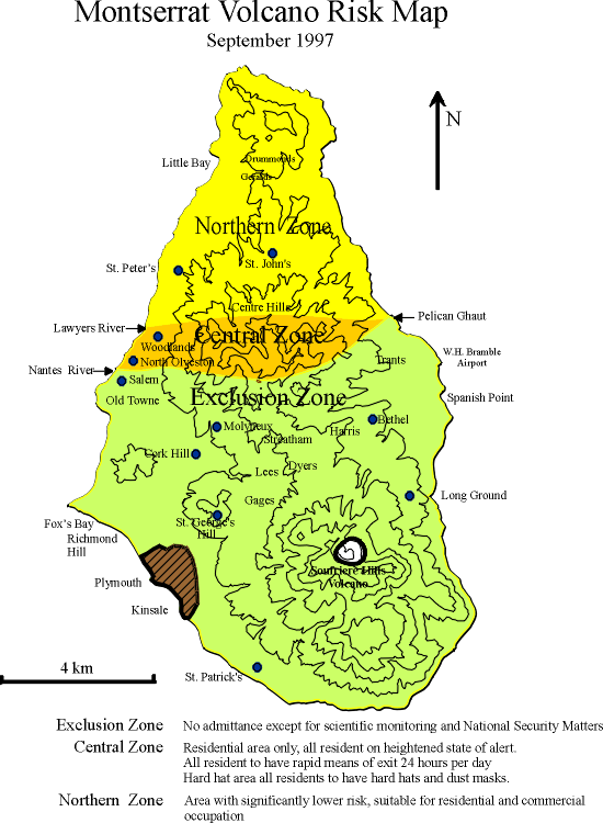
- The Montserrat Volcano Observatory (MVO) continued to monitor the volcano. Exclusion zones were set up and a hazard map created, these are still in effect today. MVO - Visit this page to see the current hazard map and images of the volcano.
- New roads built
- New capital at Little Bay
Long term impacts
- The population has reduced from 12,000 people to around 5,000 since the eruption as people moved away. In recent years some people have returned to the island.
- Unemployment rose from 7% to 50%
- Agriculture was ruined
- The north of the island was relatively undeveloped and there was a lack of housing, this resulted in rent rising by 70%
Iceland, Eyjafjallajökull, 2010
Iceland is located on the plate boundary between the North American Plate and the Eurasian Plate. Eyjafjallajökul erupted March/May 2010 prior to this it hadn't erupted since 1821. It is i relatively small volcano for the volcanic chain and is a elongated strato volcano which is covered in a large glacier. The huge glacier turned rapidly to gas resulting in a huge quantities of ash to be blown into the atmosphere and devastating lahars (volcanic mud flows). |
| Source |
In the foreground of this image you can see huge lumps of glacier and volcanic bombs which have been thrown from the top of the volcano. Watch the Top Gear clip to show you what the volcano is like and how it is different from the eruption at Montserrat.
Watch Newsround: Ore's trip to Iceland
Impacts
- Farmers had to be evacuated from their homes
- Animals died due to the ash
- Roads were destroyed by the lahars
- Schools closed
- People had to wear face mask and goggles to protect against the ash.
- Flooding from melt water
- Crops destroyed
- Brought air line travel in Europe to a stand still - many people became standard which resulted in the price of hire cars being inflated. It also meant many international flights were canceled as they couldn't fly through Europe. This had an impact on trade particularly in Africa who rely on the transport of perishable vegetables to Europe. Int total approximately 100,000 flights cancelled. Losses estimated at £80 million.
- Potentially contributed to climate change due to the large quantities of ash and carbon dioxide
 |
| Map showing the ash cloud Source: BBC |
- Grounding planes
- Monitoring of ash clouds
- Breached the highway to allow flood water to the sea and then quickly rebuilt embankments
- Evacuation of farmers
There was increasing fears that Katla the bigger sister volcano would also erupt and had shown signs of increased activity.
Mount St Helens
Supervolcano
A super volcano erupts at least 1,000km3 of material, Mount St Helens erupted about 1km3 . They are not regular volcano shape but are sunck into the ground often surrounded by higher areas. Supervolcanoes occur where there is a hotspot under the earths surface. When the large magma chamber becomes unstable it cause a string of supervolcanic eruptions. The land falls in upon itself and a caldera (a large depression) is formed. |
| See the above animation at BBC Bitesize |
Evidence for hot spot; geysers (old faithful), hot springs, string of past calderas
Potential Impacts
- Within the immediate blast zone predicted 870,000 people will die and a 1000km of land will be destroyed.
- Large ash cloud rising 40 – 50km into the atmosphere covering the immediate are in 15cm of ash. Within 5 days the ash will reach the UK.
- Kill and sicken humans and animals with respiratory problems
- Reduce sunlight which would reduce global temperature between 10-15 degrees plunging the world into a volcanic winter.
- Severely disrupt air, road and rail transport
- Cause buildings to collapse
- Contaminate water supplies
- Kill crops and other vegetation
- Clog machinery such as air filters
- Mixed with rainfall can cause lahars
- Global temperatures would fall between 12 and 15 degrees.
You could watch the film 'Supervolcano'
Formation of fold mountains
Animation
Case study: The Alps
The Alps are a fold mountain range found in Europe. They run from France to Slovenia. The highest peak being Mont Blanc. The Alps have many uses: -
- Tourism - the alps has many winter ski resorts such as Val Thornes. In the summer months these can be used for hiking and climbing. There are some glaciers which can still be used for skiing in the summer months e.g. Les Deux Alps
- HEP - the steep, narrow valleys of The Alps are easy to dam and have fast flowing glacial melt waters therefore perfect for hydro electric power. This produces over half of Switzerlands power.
- The south facing slopes are excellent for agriculture in particular cereals and in warmer locations vineyards. The most common type of agriculture is dairy farming. A practice known as transhumance, where farmers take cattle and goats from the lower pastures in winter to higher land in summer. This is less common now as tourism is more profitable. Many of the slopes have had to be terraced to support agriculture.
- Forestry is another type of industry within the alpine region.

There are however problems with human uses of The Alps including: -
- The lack of communication networks (roads, rail) make transportation difficult
- The steep slopes make farming difficult
- Difficult climate at high altitudes
- Dangers such as avalanches

Pause and test your self: Exam Questions
1. Compare and/or contrast the two earthquakes. (4 marks)
2. Describe the effects of an earthquake/volcano in a richer part of the world and a poorer part of the world. (6 marks)
3. Describe the responses to an earthquake/volcano/tsunami. (9 marks)
4. Describe the possible impacts of a supervolcanic eruption. (6 marks)
5. Describe the human uses of a fold mountain range. (8 marks)
MUST use specific case study details!
There's a mistake at the Iceland volcano section; it says 'i' instead of 'a'
ReplyDeleteThe magma becomes less dense and rises. As it moves away from the core it becomes dense again and sinks. This movement moves the crusts slowly destroying parts of the crust and creating new parts. The oceanic crust is subducted underneath the less dense continental crust forming an ocean trench. Friction between the plates causes earthquakes and the crust to melt into the mantle.In a constructive margin, two ocean plates move away from each other because the edges in the wilderness indicate the flow of currents. When the plates are removed, Magma is raised from Methal to meet the gap between the new land named Ocean Ocean Ridge.I love your top texts and we all know that this post will bring advance welfare for us thanks for sharing your helpful post...
ReplyDeletehttp://onedaytop.com/jason-aldean-jennifer-lopez-cancel-concert-events-recognizing-las-vegas-victims